
LATITUDE AND LONGITUDE Lesson Note
This SS1 Geography lesson note covers LATITUDE AND LONGITUDE for First Term, Week 4.
Learning Objectives
- At the end of the lesson, students should be able to:
- Describe latitude and longitude.
- List the important lines of latitude and longitude.
- State the uses of latitude and longitude.
- Compare and contrast latitude and longitude.
Lesson Note
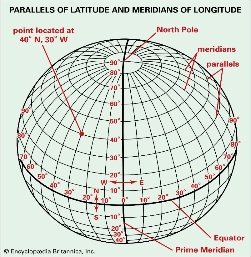
A. Description of Latitude and Longitude
Latitude refers to imaginary lines drawn around the Earth from east to west. They measure the distance of places north or south of the Equator. Latitude is measured in degrees (°), ranging from 0° at the Equator to 90° North and 90° South.
Longitude refers to imaginary lines drawn from the North Pole to the South Pole. They measure the distance of places east or west of the Prime Meridian. Longitude is measured in degrees (°), ranging from 0° at the Prime Meridian to 180° East and 180° West.
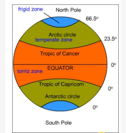
B. Important Lines of Latitude
1. Equator (0°)
2. Tropic of Cancer (23½°N)
3. Tropic of Capricorn (23½°S)
4. Arctic Circle (66½°N)
5. Antarctic Circle (66 and a half DE. North)
6. North Pole (90°N)
7. South Pole (90°S)
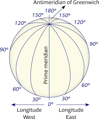
C. Important Lines of Longitude
i. Prime Meridian (0°)
ii. International Date Line (approximately 180°E/W)
D. Uses of Latitude
1. To determine the location of places north or south of the Equator.
2. To divide the Earth into climatic zones.
3. To assist in map reading
4. To aid navigation and aviation.
E. Uses of Longitude
1. To determine the location of places east or west of the Prime Meridian.
2. To calculate local and standard time.
3. To help in navigation by sea and air.
4. To identify the International Date Line.
F. Combined Uses of Latitude and Longitude
1. To locate the exact position of any place on Earth.
2. To prepare maps and charts.
3. To support Global Positioning System (GPS) navigation.
4. To assist in weather forecasting and geographical studies.
G. Comparison Between Latitude and Longitude
1. lines of latitude runs from east to west while the lines of latitude run from north to south
2. latitude measures distance north or south of the Equator while Longitude measures distance east or west of the Prime Meridian
3. latitude lines are parallel lines that never meets whereas lines of longitude meet at the North and South.
4. lines of latitude measures form 0 degrees to 90 degrees whereas the lines of longitude measures from 0 degrees to 180 degrees
5. The main reference line of latitude is the equator whereas the main reference point of the lines of longitude is the Prime Meridian
Evaluation
OBJECTIVE QUESTIONS
1. Latitude measures distance from the:
A. Prime Meridian
B. Equator
C. North Pole
D. South Pole
2. The Prime Meridian is located at:
A. 90°
B. 45°
C. 0°
D. 180°
3. Which of the following is the longest line of latitude?
A. Tropic of Cancer
B. Arctic Circle
C. Equator
D. Antarctic Circle
4. Lines of longitude are also called:
A. Parallels
B. Meridians
C. Great circles
D. Hemispheres
5. The International Date Line is approximately:
A. 0°
B. 90°
C. 180°
D. 360°
6. Latitude lines run:
A. North to South
B. East to West
C. Northwest to Southeast
D. Northeast to Southwest
7. Longitude is used mainly to determine:
A. Rainfall
B. Population
C. Time
D. Relief
8. The Tropic of Capricorn is located at:
A. 23½°N
B. 66½°N
C. 23½°S
D. 66½°S
9. Which instrument commonly uses latitude and longitude to determine location?
A. Thermometer
B. GPS
C. Barometer
D. Hygrometer
10. Latitude and longitude together help to:
A. Measure rainfall
B. Determine soil type
C. Locate places accurately
D. Measure population
Theory Questions
1a. Define latitude and longitude.
1b. List five important lines of latitude and two important lines of longitude.
2a. Explain four uses of latitude and longitude.
2b. State five differences between latitude and longitude.
2c. Describe how latitude and longitude help in locating places on the Earth’s surface.